


Why Minnesota’s Utility Infrastructure Projects Require Engineering-Grade Site Documentation
Utility infrastructure projects throughout Minnesota involve engineering firms, utility companies, renewable energy developers, surveyors, civil contractors, municipal agencies and design-build teams working across existing roads, utility corridors, greenfield developments, transportation infrastructure and public works projects. Unlike general commercial photography that simply records a construction site, engineering-grade documentation provides standardized existing site conditions, pre-construction verification and location-aware visual records that support engineering design, utility coordination, permitting, construction planning and long-term project management.
Accurate visual documentation collected immediately following survey and utility locates helps project teams verify existing conditions before design begins, reducing uncertainty, minimizing field revisits and improving communication throughout every phase of engineering, construction and asset management.
…………………………………………………………………
Why Utility Infrastructure Projects Demand Standardized Existing Site Conditions Documentation
Engineering decisions depend on consistent, repeatable and well-organized field documentation rather than isolated site photographs. Utility corridors, renewable energy developments, transportation improvements, municipal infrastructure and civil construction projects require standardized photography that documents existing conditions from the same perspectives every time, allowing engineers, designers and project managers to compare sites, verify field conditions and coordinate multiple disciplines with confidence.
Engineering-grade documentation combines high-resolution photography, FAA Part 107 aerial imagery, street-level documentation, cardinal-direction photographs, GPS-aware image organization and engineering-ready deliverables that create a permanent visual record supporting design verification, regulatory compliance, GIS integration, utility coordination and future construction activities.
…………………………………………………………………
How We Standardize Utility Infrastructure Documentation Across Minnesota
Every infrastructure project follows a consistent documentation workflow designed to reduce site uncertainty, improve engineering accuracy and support efficient project coordination.
✔ Every project receives 20–50+ (Unlimited Images) professionally documented high-resolution site photographs captured using a standardized engineering workflow.
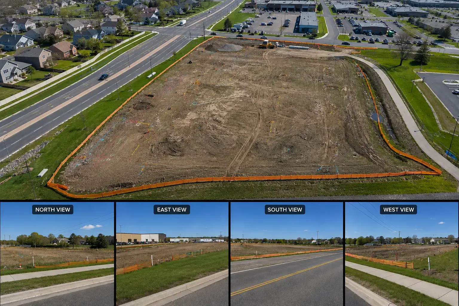
✔ One FAA Part 107 bird’s-eye aerial image is captured immediately following survey and utility locates, providing engineers with valuable project context before design activities begin.
✔ Street-level documentation records existing infrastructure, access points, roadway conditions, utility corridors and surrounding site characteristics from consistent ground-level perspectives.
✔ Four cardinal-direction photographs (North, East, South and West) establish standardized reference views that simplify engineering review and future site comparisons.
✔ GPS-aware image organization allows project teams to quickly identify, manage and retrieve documentation across multiple locations and large infrastructure programs.
✔ Engineering-ready digital deliverables support engineering firms, utility companies, renewable energy developers, surveyors, municipal agencies, civil contractors and design-build teams throughout planning, permitting, construction and asset management.
✔ Standardized reporting improves collaboration between engineers, designers, survey crews, environmental consultants and construction managers while reducing unnecessary field revisits.
✔ Consistent documentation supports existing site conditions reports, pre-construction verification, utility corridor documentation, GIS integration, regulatory compliance and long-term infrastructure asset management across projects throughout Minnesota.
…………………………………………………………………
Why Minnesota Engineering & Utility Professionals Trust UAV Vision Media
 Awarded by Quality Business Awards #1 BEST RATED 2025 – Photographer in South St. Paul, MN
Featured by Peerspace Among the Best 9 Photographers in Minneapolis
No Photos Limit
✔ Fully Insured FAA Part 107 Certified Drone Pilot
✔ Engineering-grade standardized documentation workflows
✔ GPS-aware image organization
✔ One standardized workflow across multiple project sites
✔ 24–48 Hour Turnaround
✔ Serving Woodbury, Savage, Eagan, the Twin Cities, Minnesota & Beyond
…………………………………………………………………